MapStats/CulturalGeographyLesson: Difference between revisions
No edit summary |
No edit summary |
||
| (One intermediate revision by the same user not shown) | |||
| Line 2: | Line 2: | ||
In this lesson, we will study a few parts of the United States cultural geography. |
In this lesson, we will study a few parts of the United States cultural geography. |
||
===Language=== |
|||
Spanish and French are spoken by millions of Americans. Where do we expect to find the most Spanish speakers? The most French speakers? Numbers of French and Spanish speakers should tell us about both history and modern culture - but a simple list of states would make it difficult to find patterns. A color-coded map offers a closer look. |
Spanish and French are spoken by millions of Americans. Where do we expect to find the most Spanish speakers? The most French speakers? Numbers of French and Spanish speakers should tell us about both history and modern culture - but a simple list of states would make it difficult to find patterns. A color-coded map offers a closer look. |
||
This image captures Spanish and French speakers in the |
This image captures Spanish and French speakers in the USA map. You can also check the North America map. |
||
[[Image:MapStats3.jpg]] |
[[Image:MapStats3.jpg]] |
||
| Line 12: | Line 14: | ||
* Does the map match what we know from history? |
* Does the map match what we know from history? |
||
* It had been hundreds of years since the French controlled Louisiana, yet the state continues to be affected by that influence. The capital, Baton Rouge, has a French name, and the city of New Orleans is famous for the French Quarter. How was your culture |
* It had been hundreds of years since the French controlled Louisiana, yet the state continues to be affected by that influence. The capital, Baton Rouge, has a French name, and the city of New Orleans is famous for the French Quarter. How was your culture set by history? |
||
====Beyond MapStats==== |
|||
American English can differ from state to state. Consider the words soda, pop, coke, and tonic - words Americans use for soft drinks such as Coca-Cola. In this map, blue=pop, red=coke, yellow=soda, and lighter areas are more divided. |
|||
http://www.popvssoda.com/countystats/total-county.html |
|||
* What do you think about the divisions on the map? What separates one region from another? |
|||
* In the central US, around St. Louis, there is a large "island" of people who use the word "soda". How could something like that happen? |
|||
Latest revision as of 04:12, 13 June 2009
Cultural geography is the study of how languages, religions, and pop culture spread over the globe. Maps of culture today can hint at many other facts. Regions separated by oceans and mountain ranges adopt different ideas. Countries which trade with each other find common languages to do business. The culture of a city is closely tied to its history.
In this lesson, we will study a few parts of the United States cultural geography.
Language
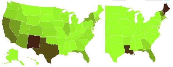
Spanish and French are spoken by millions of Americans. Where do we expect to find the most Spanish speakers? The most French speakers? Numbers of French and Spanish speakers should tell us about both history and modern culture - but a simple list of states would make it difficult to find patterns. A color-coded map offers a closer look.
This image captures Spanish and French speakers in the USA map. You can also check the North America map.

Consider some historical facts: French colonies existed for generations in Canada and Louisiana, and Spanish explorers founded missions throughout Mexico and what is now the southwest United States.
- Does the map match what we know from history?
- It had been hundreds of years since the French controlled Louisiana, yet the state continues to be affected by that influence. The capital, Baton Rouge, has a French name, and the city of New Orleans is famous for the French Quarter. How was your culture set by history?
Beyond MapStats
American English can differ from state to state. Consider the words soda, pop, coke, and tonic - words Americans use for soft drinks such as Coca-Cola. In this map, blue=pop, red=coke, yellow=soda, and lighter areas are more divided.
http://www.popvssoda.com/countystats/total-county.html
- What do you think about the divisions on the map? What separates one region from another?
- In the central US, around St. Louis, there is a large "island" of people who use the word "soda". How could something like that happen?