Geoquiz: Difference between revisions
Jump to navigation
Jump to search
Gmccreight (talk | contribs) (Updated .xo file version) |
Gmccreight (talk | contribs) (Added a Versions Section) |
||
| Line 13: | Line 13: | ||
= Screenshot = |
= Screenshot = |
||
[[Image:GeoquizActivity.jpg|380px]] |
[[Image:GeoquizActivity.jpg|380px]] |
||
== Versions == |
|||
* 2 |
|||
** Added a message about which keys to use. |
|||
** Discovered a mistake in the MANIFEST which created double files in the .xo zip file (no big deal, but fixed) |
|||
* 1 |
|||
** Released to the wild |
|||
== Information for programmers == |
== Information for programmers == |
||
Revision as of 20:52, 22 April 2008
|
Geoquiz
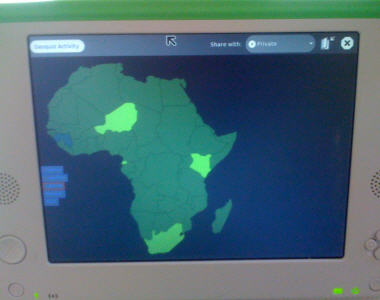
Geoquiz is a geography guessing game.
Screenshot
Versions
- 2
- Added a message about which keys to use.
- Discovered a mistake in the MANIFEST which created double files in the .xo zip file (no big deal, but fixed)
- 1
- Released to the wild
Information for programmers
This little Activity is still a work in progress, but it's pretty functional already.
- uses SVG for the country shapes
- only has a map of Africa, and only displays the names in English
- intended to be multi-player, but haven't written the code for that yet
- when you finish the game it crashes rather than having a cool "TADA" type screen
- the SVG colors aren't displaying like I think they should, so the highlighted coutries are actually purple instead of a nice yellow-orange
- the code is hosted at [1]
