OLPC world map: Difference between revisions
Jump to navigation
Jump to search
No edit summary |
No edit summary |
||
| Line 4: | Line 4: | ||
<gallery> |
<gallery> |
||
Image:olpc-countries-jun-2010.jpg|Countries with 500+ kids and teachers w/ XOs |
Image:olpc-countries-jun-2010.jpg|Countries with 500+ kids and teachers w/ XOs, June 2010 |
||
Image:olpc-countries-all.jpg|Countries w/ 100+ kids and teachers w/ XOs |
Image:olpc-countries-all.jpg|Countries w/ 100+ kids and teachers w/ XOs, Feb 2010 |
||
</gallery> |
</gallery> |
||
Revision as of 21:53, 12 August 2010
For reference, see also this general non-OLPC political map w/ country labels.
2010 maps
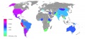
Countries with 500+ kids and teachers w/ XOs, June 2010
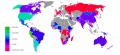
Countries w/ 100+ kids and teachers w/ XOs, Feb 2010


2007 maps
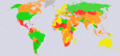
The information in these maps is obsolete since 2007.
There's a map based on Deployments info at http://maps.google.com/maps/ms?ie=UTF8&hl=en&msa=0&msid=107887635573341686661.00045a8f74844ef1681f8&z=2
Large 3472x1626 GIF
(~1,380 KiB)
Medium 1200x562 JPG
(~56 KiB)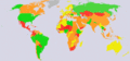
Small 440x206 GIF
(~31 KiB)


Enumeration by status
See Deployments for status on OLPC country deployments. See OLPC status by country in 2007 for historical country status