MapStats: Difference between revisions
(Undo revision 236792 by Seakean001 (Talk)) |
|||
| (16 intermediate revisions by 2 users not shown) | |||
| Line 1: | Line 1: | ||
| ⚫ | |||
=MapStats= |
|||
| ⚫ | |||
The MapStats activity allows students to view and edit maps without internet access. It also supports online services to share more data, regional maps, and lesson plans. |
The MapStats activity allows students to view and edit maps without internet access. It also supports online services to share more data, regional maps, and lesson plans. |
||
'''Download for XO''': http://www.andrew.cmu.edu/user/ndoiron/MapStats.xo |
|||
| ⚫ | |||
[[Image:MapStats8.png]] |
|||
==Mapping Technology== |
==Mapping Technology== |
||
One of the leading technologies in the developing world is development and content-creation in mapping. These programs are often called Geographic Information Systems (GIS). |
One of the leading technologies in the developing world is development and content-creation in mapping. These programs are often called Geographic Information Systems (GIS). |
||
==Included Maps== |
===Included Maps and Data=== |
||
North America, South America, Europe, Africa, Asia, Middle East, United States, Central America/Caribbean, Australia/Oceania |
|||
| ⚫ | |||
==Included Data== |
|||
| ⚫ | |||
=Learning with MapStats= |
=Learning with MapStats= |
||
| Line 19: | Line 19: | ||
==Level 1: Using Maps for Information== |
==Level 1: Using Maps for Information== |
||
===Closing the Digital Divide=== |
===Closing the Digital Divide=== |
||
[[MapStats/DigitalDivideLesson|Lesson Plan]] |
|||
The OLPC project is one of many programs working to close the Digital Divide, the gap between people with and without computer access. Computers and the internet allow people unparalleled access to education, information, and media. It also empowers people to share their work and participate in high-tech jobs. |
The OLPC project is one of many programs working to close the Digital Divide, the gap between people with and without computer access. Computers and the internet allow people unparalleled access to education, information, and media. It also empowers people to share their work and participate in high-tech jobs. |
||
A map can show how access to technology is changing the globe. Maps of internet users/capita on the Asian |
A map can show how access to technology is changing the globe. Maps of internet users/capita on the Asian continent show how many more countries have plugged into the global network over just the last 8 years. One wonders what kind of online communities and resources will exist once all countries gain widespread internet access. |
||
[[Image:MapStats2.jpg]] |
[[Image:MapStats2.jpg]] |
||
===Cultural Geography: English, Spanish, and French in the US=== |
===Cultural Geography: English, Spanish, and French in the US=== |
||
[[MapStats/CulturalGeographyLesson|Lesson Plan]] |
|||
Spanish and French are spoken by millions of Americans. Where do we expect to find the most Spanish speakers? The most French speakers? |
Spanish and French are spoken by millions of Americans. Where do we expect to find the most Spanish speakers? The most French speakers? |
||
| Line 33: | Line 36: | ||
[[Image:MapStats3.jpg]] |
[[Image:MapStats3.jpg]] |
||
===Global Health: Malaria Crisis=== |
|||
===Statistics: Mobile Phones=== |
|||
[[MapStats/MobilePhonesLesson|Lesson Plan]] |
|||
MapStats includes options to see mobiles (cell phones) by density and by capita. Which people would be interested in which map? How are people around the world using cell phones? Read the lesson plan for more information. |
|||
==Level 2: MapStats as a Database== |
==Level 2: MapStats as a Database== |
||
| Line 39: | Line 47: | ||
===Highlighting Coastal Regions=== |
===Highlighting Coastal Regions=== |
||
[[MapStats/BasicQueries|Lesson Plan]] |
|||
A simple data query can be used to highlight regions that have a coastline. If a region is on the coast, its "coastline" value will be greater than zero. Enter the query exactly as it is shown here: |
A simple data query can be used to highlight regions that have a coastline. If a region is on the coast, its "coastline" value will be greater than zero. Enter the query exactly as it is shown here: |
||
| Line 46: | Line 56: | ||
===US History: Statehood=== |
===US History: Statehood=== |
||
[[MapStats/StatehoodQueries|Lesson Plan]] |
|||
| ⚫ | |||
| ⚫ | |||
| ⚫ | |||
((Example coming)) |
|||
Try the following queries and discuss their meaning: |
Try the following queries and discuss their meaning: |
||
* " |
* "territory < 1776" (independence was declared in 1776, so there are none selected) |
||
* " |
* "territory = 1776" (original 13 colonies which declared independence in 1776) |
||
* "statehood > 1789" (states which joined after the US Constitution was ratified) |
|||
* "statehood < 1860" (states which had to choose sides in the American Civil War) |
* "statehood < 1860" (states which had to choose sides in the American Civil War) |
||
* "statehood > 1959" (no states have been added since 1959) |
* "statehood > 1959" (no states have been added since 1959) |
||
| Line 71: | Line 84: | ||
[[Category:Activities]] [[Category:Maps]] |
[[Category:Activities]] [[Category:Maps]] |
||
{{Activity page |
|||
|icon=Image:MapStatsIcon.svg |
|||
|genre=Math and Science |
|||
|short description=Introduces students to maps and statistics with color-coded maps. Includes several lesson plans and interesting data sets. More advanced classes can learn the concept of queries and create their own data sets. |
|||
|contact person=User:Ndoiron |
|||
|language codes=en |
|||
|bundle URL=http://www.andrew.cmu.edu/user/ndoiron/MapStats.xo |
|||
|activity version=0.3 |
|||
|releases=8.2.0 (767) |
|||
|devel status=4. Beta |
|||
}} |
|||
Latest revision as of 13:01, 2 June 2010
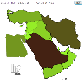
MapStats introduces students to mapping technology/GIS, statistics, and databases. The program can be used to teach students about cultural geography, the digital divide, global health, and history (see the Learning section).
The MapStats activity allows students to view and edit maps without internet access. It also supports online services to share more data, regional maps, and lesson plans.
Download for XO: http://www.andrew.cmu.edu/user/ndoiron/MapStats.xo
Mapping Technology
One of the leading technologies in the developing world is development and content-creation in mapping. These programs are often called Geographic Information Systems (GIS).
Included Maps and Data
North America, South America, Europe, Africa, Asia, Middle East, United States, Central America/Caribbean, Australia/Oceania
Population, area, GDP, year of independence/statehood, major languages, population density, spread of internet and mobile phones, health information, coastline, and historic demographics
Learning with MapStats
Level 1: Using Maps for Information
Closing the Digital Divide
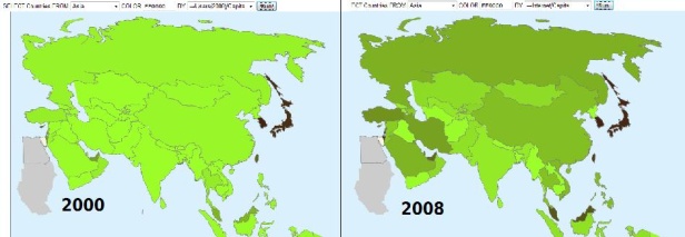
The OLPC project is one of many programs working to close the Digital Divide, the gap between people with and without computer access. Computers and the internet allow people unparalleled access to education, information, and media. It also empowers people to share their work and participate in high-tech jobs.
A map can show how access to technology is changing the globe. Maps of internet users/capita on the Asian continent show how many more countries have plugged into the global network over just the last 8 years. One wonders what kind of online communities and resources will exist once all countries gain widespread internet access.
Cultural Geography: English, Spanish, and French in the US
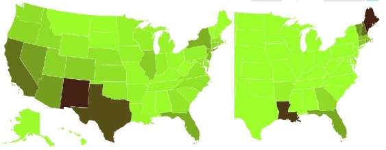
Spanish and French are spoken by millions of Americans. Where do we expect to find the most Spanish speakers? The most French speakers?
Cultural geography is the study of how languages, religions, and pop culture spread over the globe. A map of French and Spanish speakers in the US tells about both history and modern culture. A map gives an impression different from a simple list of statistics.
Statistics: Mobile Phones
MapStats includes options to see mobiles (cell phones) by density and by capita. Which people would be interested in which map? How are people around the world using cell phones? Read the lesson plan for more information.
Level 2: MapStats as a Database
MapStats can create maps with custom colors, data ranges, and country selections. The system is based on SQL, a globally-popular language for database requests. A basic understanding of "a < b" or "a > b" is necessary for these examples.
Highlighting Coastal Regions
A simple data query can be used to highlight regions that have a coastline. If a region is on the coast, its "coastline" value will be greater than zero. Enter the query exactly as it is shown here:
When you click "Run", the map will apply the selected color (red) to African countries with coastline. Notice how many countries, even those that are mostly inland, have some access to the ocean. Students may be able to guess the reason for this: so that the nation could trade by sea.
US History: Statehood
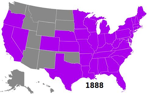
American students may know all 50 of the United States. But there have been only 50 states since 1959. Since each state in the map "knows" when it was accepted to the Union, you can query the map to see the map of the US at any point in its history:
Try the following queries and discuss their meaning:
- "territory < 1776" (independence was declared in 1776, so there are none selected)
- "territory = 1776" (original 13 colonies which declared independence in 1776)
- "statehood > 1789" (states which joined after the US Constitution was ratified)
- "statehood < 1860" (states which had to choose sides in the American Civil War)
- "statehood > 1959" (no states have been added since 1959)
Note that "statehood" does not work on maps other than USA and North America. You should use "independence" on maps of countries.
Level 3: Creating and Sharing Maps
Viewing Online Data
Viewing Online Maps
Creating and Sharing Data
Programming
The program mainly relies on JavaScript within SVG maps from Wikipedia. You can add your own regional map if it is in SVG format.
The offline data is stored in JavaScript arrays.
Activity Summary
| Icon: | Sugar icon::Image:MapStatsIcon.svg |
| Genre: | Activity genre::Math and Science |
| Activity group: | ,|x|Activity group::x}} |
| Short description: | Short description::Introduces students to maps and statistics with color-coded maps. Includes several lesson plans and interesting data sets. More advanced classes can learn the concept of queries and create their own data sets. |
| Description: | |
| Maintainers: | ,|x|Contact person::x}} |
| Repository URL: | |
| Available languages: | ,|x|Available languages::x}} |
| Available languages (codes): | ,|x|Language code::x}} |
| Pootle URL: | |
| Related projects: | Related projects,|x|Related projects::x}} |
| Contributors: | ,|x|Team member::x}} |
| URL from which to download the latest .xo bundle | Activity bundle::http://www.andrew.cmu.edu/user/ndoiron/MapStats.xo |
| Last tested version number: | Activity version::0.3 |
| The releases with which this version of the activity has been tested. | ,|x|Software release::x}} |
| Development status: | Devel status::4. Beta |
| Ready for testing (development has progressed to the point where testers should try it out): | ,|x|Ready for testing::x}} |
| smoke tested : | |
| test plan available : | |
| test plan executed : | |
| developer response to testing : |


