XO Korea/XO Deployment
환영합니다 | Portal | XO Korea | Deployment | Content | Hardware | Software | Mesh Network | Ethics | LOS | XO City | Accreditation | Consortium
This page is to show the progress of XO deployment in Korea (both South and North).
Overall Deployment
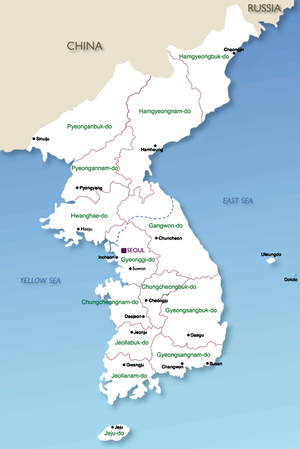
The regional status of XO deployment in Korea will be estimated by the availability of Korean Mesh Network.
- If residents in a particular region are fully covered by wireless mesh network composed of XO and its variations, the region is colored Green.
- If more than a half residents in a region is covered by wireless mesh network composed of XO and its variations, the region is colored Red.
- If some residents in a region is covered by wireless mesh network composed of XO and its variations, the region is colored Orange.
- If no residents in a region is yet covered by wireless mesh network composed of XO and its variations, the region is colored Yellow.
- If no residents in a region WILL BE covered, in a near future, by wireless mesh network composed of XO and its variations, the region is colored Gray, and currently the North part of Korea (North Korea) is.
From OLPC Viewpoint: How does the color/status scheme work?
If using the OLPC color scheme, Korean XO deployment may be described as;
| to enlarge & text region list |
Basically regions in the Korea map are soon coded in four colors (plus a generic one):
| green | those regions we plan to pilot Currently: Argentina, Brazil, Ethiopia, India, Libya, Nepal, Nigeria, Pakistan, Peru, Romania, Russia, Rwanda, Thailand, United States, Uruguay |
|---|---|
| red | those regions we plan to include in the post-launch phase |
| orange | those regions who have expressed interest at the Local-Ministry-of-Education (교육청) level or higher |
| yellow | those regions who are currently seeking local governments' support |
| gray | regions under the radar or that have not made contact with the XO Korea |
For a larger image and textual list you can click on the image on the right, or see the status by Region page
Educational Deployment: Rabbiting
There are more than 30,000 schools, colleges, or other educational facilities in Korea. You can see rabbit ears at a school's location if the school deploys XO.
Governmental Deployment
There are more than 10,000 states, cities, counties, or other governmental organizations in Korea. You can see rabbit ears at a government's location if the local government deploys XO for their residents.
See XO Korea/Table of Contents for detailed information.
Public Deployment
There are more than 30,000 governmental corporations, foundations, associations, or other public organizations in Korea. You can see rabbit ears at a public entity's location if the entity deploys XO.
See XO Korea/Table of Contents for detailed information.
Business Deployment
It's the only sector described not geographically, but by categories. See XO Korea/Table of Contents for detailed information.

