OLPC Papua New Guinea
Cook Islands -French Polynesia - Kiribati - Nauru - New Caledonia - Niue - Palau - Papua New Guinea - Samoa- Solomon Islands - Tonga - Tokelau - Tuvalu - Vanuatu
Trials in PNG
Deployments in PNG will commence in June 2008 at the following sites:
- Gaire, Central Province
- Drekikir, East Sepik Province
- Buka, Bougainville Province
Click any picture to enlarge:
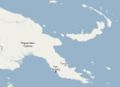
Location of PNG
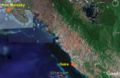
Location of Gaire
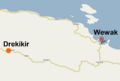
Location of Drekikir


Contacts
- Dr Joseph Pagelio, Secretary, Department of Education, PO Box 446, Waigani NCD Phone: 301 3447 Fax: 323 1031
- Brian Monie, senior Policy Officer, Ministry of Education
- David Leeming
- Ian Thomson
Content and Localisation
Localisation projects have been opened on the OLPC Pootle server for Tok Pisin language (PNG Pidgin)
Gaire

Gaire is located about 45 minutes drive from Port Moresby. It is the site of a rural community VSAT access point, set up under the Secretariat of the Pacific Community (SPC)'s Pacific Rural Internet Connectivity System (Pacific RICS) project.
Breaking news, June 13th 2008: pictures of Gaire Primary school, 53 laptops, both streams of the Grade 3 saturated (Grade 3 is the first grade in the PNG primary education system). Gaire Primary School is located at 9.6698S, 147.4086E (WGS84), sea level.
None of the children have any experience of computers before. Of the teachers, only the Principal and one or two others are computer literate.
See latest photos!
Drekikir
Drekikir Admin Primary School is located in East Sepik Province, near Wewak. This school is participating in the EU-funded Improvement of Rural Primary Education Facilities (IRPEF) project, based in Madang. The IRPEF is collaborating with the Department of Education and OLPC Oceania to implement the trial.

This trial took place between 16th - 20th June 2008. More information will be posted here soon.
Dreikikir is located at 3.57516S, 142.76946E at altitude 380m.
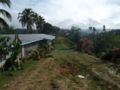
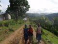
Some pictures of the Drekikir region can be seen here: [1]
Useful links
Photo Gallery
Click any picture to enlarge:
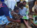
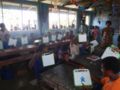
Gaire: Each child receives an XO
Gaire: Opening the laptops
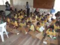
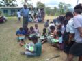
Discovery.....(Gaire)
Gaire: Within the first hour, there is much activity...
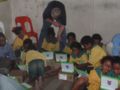
Gaire: Memorise activity
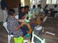
Gaire: Teachers training
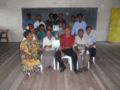
Teachers of Gaire Primary School
Dreikikir Admin Primary School
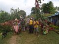
Two Guardians of Dreikikir Admin Primary School
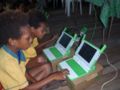
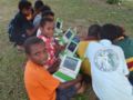
Dreikikir: Two girls absorbed by the XO
Dreikikir: Training in groups outside
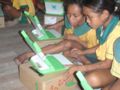
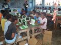
Dreikikir: Boys using Paint, Speak and Record during training

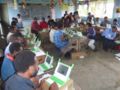
Dreikikir: Training in the classroom
Dreikikir: Teacher Training
Dreikikir: Teacher Training
Dreikikir: Minister arriving for the official launching
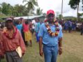
Dreikikir: Education Minister and MP for Dreikikir, Hon Tony Amos arriving for the official launching

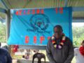
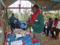
Dreikikir: Brian Monie, Senior Development Officer, Ministry of Education speaking at the hand-over ceremony
Dreikikir: Joseph Ouyoumb, Provincial Education Advisor, East Sepik
Dreikikir: Chris Sangisi, Standard Officer, Dreikikir District
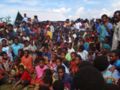
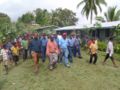
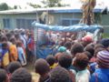
Dreikikir: People from the Dreikikir community at the hand-over ceremony
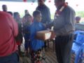
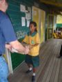
Dreikikir: Handing over laptops to Grade 3 students
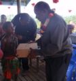
Dreikikir: Handing over laptops to Grade 3 students
Dreikikir: Got laptops!
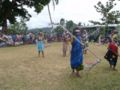
Dreikikir: Dancing at the official opening
Dreikikir: Dancing at the hand over ceremony
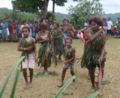
Dreikikir: Puppet dancing show at the hand over ceremony
Dreikikir: Welcome to the hand over ceremony


